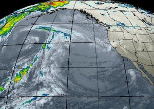
We have another cold storm beginning to work its way down the coast off of British Columbia today.
Snow should begin falling on the mountain during the afternoon on Thursday and will last until Saturday.
The heaviest snow will fall Thursday night into Friday.
If you thought the snow with the last storm was light, wait until you see what is coming.
The cold with this storm will be as big of a story as the snowfall.
We are going to get some decent snow totals although we are only working with 1-2 inches of liquid.
The ridge wants to setup near the Aleutians or maybe even further North over the Bering Sea.
How the storms coming from the two directions interact is the question.
The storms coming down from the North will be cold.
I am still not seeing anything long-term that would stop this pattern.
The next two weeks should be quite stormy with normal Sierra style snow adding to our already impressive totals.
