NWS reported a pressure reading in the center of the storm around 2 a.m. of 981 mb.
This has caused the high winds that closed the resort for the day.
That will increase the snowfall intensity this morning.
Heavy snow will continue through the day and into tonight as the front is slow to move through.
Once the cold front clears the snow becomes showery overnight and into Monday.
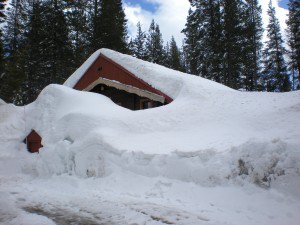
Weekend storm total on the mountain should end up around 6-7 feet.
Cold unstable airmass and a continued moist flow off the Pacific will continue the snow showers into Monday night.
We could pick up several more inches Monday and Monday night.
Tuesday looks like the one short break before the next storm moves in as early as late Tuesday night.
The first wave in the next series of storms pushes in by Wednesday.
This first wave doesn’t look as strong with several inches likely.
Next wave moves in on Thursday and is strong and lasts through Friday.
This one could drop around 2-3 feet.
The third wave moves in on Sunday and models are not in agreement on the strength.
