Snow showers fizzled out overnight as we lost the heating from the sun.
The heavy snow pushes into all areas by Wednesday morning.
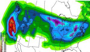
The snowfall from this first storm should be around 15-20 inches at the base and 20-25+ inches on top.
The snow showers behind the main storm will last into Friday night.
The snowfall from this second storm should be around 18-24 inches at the base and 2-3 feet on top.
Third storm is now forecasted to arrive faster now by Saturday afternoon lasting into Sunday morning.
This storm is weaker than the first 2 storms.
The snowfall from this third storm should be around 10-15 inches at the base and 15-20 inches on top.
Storm totals by Sunday morning will be around 4-5 feet at the base and 5-7 feet on top.
Basically we are getting a replay of the last 4 days over the next 4 days.
The next chance of a storm is the first weekend in April.
The long-range models look typical of spring with a fast progressive pattern, cut-offs, and inconsistency.
