We have a break today before the next storm is ready to dive in tomorrow.
This storm will be a much colder storm with a drier & fluffier snow.
We could see snow showers start as early as tonight ahead of the main storm.
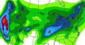
Total liquid by Saturday is 1-1.25 inches.
Looking for 15-20 inches at the base and 20-25 inches on top by Saturday.
This could keep snow showers going off and on Saturday and Sunday with several more inches possible.
Then the main low pushes in Sunday afternoon into Monday bringing another round of heavier snow.
The snow showers could linger into Monday night.
If you thought that was the end you are wrong.
A break Tuesday and Wednesday before the next cold storm dives down from the Gulf of Alaska.
Long-range models keep the storms coming going towards the end of the month.
Looking at teleconnections they look more favorable for storms as we go out 2 weeks.
Stay tuned……BA
